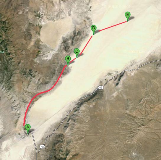
Finding the Launch Site
The directions below assume you first get to Gerlach NV, USA.

Black Rock is a "dry" lake about 100 miles north of Reno Nevada. It's very empty country, just about the only town nearby is the town of Gerlach.
From Reno:
Take Interstate 80 East from Reno, about 30 miles from Reno
take the Wadsworth/Pryamid Lake exit #43.
(The last cheap gas is available at the I80 truck stop at this exit.)
Take highway 447 north about 75 miles to Gerlach.
As you approach the town of Nixon don't take the Pyramid lake exit,
instead drive through Nixon and continue north to Gerlach.
About 5 miles before you get to Gerlach you will pass through the company town of Empire.
(The store by the road here is the only thing locally that can be considered a supermarket.
Stop on your way through to buy ice and anything else you forgot.)
when going through all these little towns - they are notorious speed traps. If in doubt of what the speed limit is, just slow down. If you can see homes and buildings near the road then you're most likely in a slower speed zone.
From California:
Take I80 East from the Bay Area through Sacramento
to Reno, follow the directions above.
Some people from the north (or Oregon) take CA 299 from Alturas to NV 447 to Gerlach.
From Utah and states east:
Take I80 West through Winnemucca and then take the Wadsworth exit, take 447 north (see above).
From the Reno Airport:
Take 395 north to Reno then I80 East.
The directions below assume you first get to Gerlach NV, USA.
Finding the Launch Site

This information up on the Fruity Chutes website making it easy to read on your portable devices here: DIRECTIONS
Here is a KML file for Google Earth or your portable device.